

Walking numbers game
Surfers, sunbathers and nudists, they are all there on the South West Coastal Path along with dog walkers, day trekkers and backpackers. And figures from Natural England suggest that number is growing, with 8.7 million people using the path in 2014, an 11 per cent increase from 2010. That is a huge number and got me thinking about how many fellow backpackers would be met on a two-night weekend trek from Bournemouth to Weymouth ‑‑ roughly 40 miles and Scafell Pike plus Ben Nevis in undulating height.
Natural England does not have figures for people walking the coastal path each year, but about 100 people a year tell the South West Coast Path Association that they have completed the route, and the association estimates there are many more who walk the length of the path.
So out of curiosity the decision is made to keep a count of people. They have to be coast path walkers, preferably with rucksacks, but not dog-walking locals, or people wending their way to the beach otherwise trying to keep a count of all the different folks would prove a distraction to the enjoyment of the walk. Besides you need to be able to keep the running total in your head and not feel like some clip-board-carrying, bean-counting civil servant of a backpacker.
To add a twist, for walkers to be included in the count they had to be greeted with “hello”, “great day” or “lovely weather” and they had to reply ‑ with one “hello” or other greeting from a group of walkers counting for the number of people in the party.
Swanage, how I love ya….
This walk is a piece of unfinished business, the aim being to walk through the army ranges to Lulworth Cove, which had been out of bounds on a walk along the southern section of the coastal path years ago.
Off the train at Bournemouth on a Friday afternoon, chilli noodles, bananas and tea are bought at the Tesco near the railway station before boarding the number 50 bus to Sandbanks and the ferry to South Haven. Beautiful sunny views of Poole Bay from Hengistbury point to the east and Foreland to the west are a welcome sight at the path’s start on the beach. On the wet sand of the water’s edge along Studland there is a chat with two beach wardens ‑ without establishing what they are wardening ‑ as we stroll through the naturist section. They start the count at two, mainly because they are coast-path walking non-locals, but no rucksacks. Might need a recount.
Up onto the headland at Redend Point, the place is littered with holidaymakers and dog walkers and five walkers, with day sacks. One “lovely evening” from me and a “hello” back takes the score to seven. A diversion, to avoid a small landslip on the path, passes the Bankes Arms, which is swarming with early evening drinkers of all shapes, sizes, and their dogs. A pint is so tempting but there is a pressing need to make mileage.

Above Warren Wood, blister-preventative plasters are applied to the feet, two mountain bikers zip past replying to a greeting with stretched-out “hellos” (count them for nine, they had rucksacks). A couple with inquisitive cocker spaniels and rucksack stop to chat (11). The earth is rock hard heading for Old Harry Rocks – great early evening vistas here and seahorses in the waters below – with the
remnants of tourists (no hellos) making their way back to Studland. A Dutch family replies to a “hi” with a “good evening, isn’t it beautiful here?” in perfect English. They have a rucksack (14) and are the last people on the path until well beyond Ballard point, a climb of about 100 metres hugging the cliff edge and catching an invigorating sea breeze at every step. A jogger clad in Manchester United shirt – and mini-sac – pants “hello” and veers off along the Purbeck Way. (15). A teenager supping from a bottle nods as the winding route through gorse and shrubs gives way to the back streets of New Swanage, a quiet ramshackle suburbia of holiday homes that swallows up the signposts for the coast path. On the busy sea front at (old?) Swanage, 20 minutes queuing for crisp fresh-cooked fish and chips from a chipper next to the tourist information is so worth the wait. A yummy fresh fish supper is wolfed down while sharing a picnic table with a family of four from Airdrie, on their first visit and on their first night on the English south coast. Have fun.
The expectation had been to come across the odd backpacker or two, starting or finishing an adventure along the coastal path. But sat on the picnic table outside the chipper there are no walkers, let alone backpackers. But Swanage is full of Friday night revellers. It is well past eight o’clock, with rain clouds drawing in, as the trudge through hoards of them at the top end of the town begins, heading for Peveril Point. Through sloping greenery and straggling houses the path heads for Durlaston Point, where a wooded cliff-top section is too busy with dog walkers and their excitable hounds for a quiet pitch. A pub earmarked as a water stop – and a place to grab some of those one-cup milk cartons ‑ does not materialise and the need to find a pitch outweighs thoughts of hunting for it.
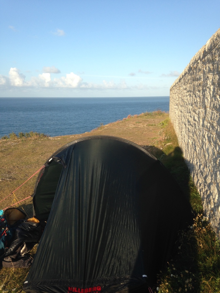
Rounding Durlaston, a courting couple are the last people encountered that night as solitude and the wide sea views return. A bird-watching hut above Tilly Whim caves is lodged as an emergency bothy and a thought of returning to it comes up when a potential pitch below Anvil Point lighthouse proves too knolly and possibly boggy. But always reluctant to turn back, the decision is made to take the next half-reasonable, dry, pitch and that is by the side of the lighthouse wall on a thin strip of soft ground. Light fading. Rain moving in. Wind speed picking up. We are in. The Neoair mattress evens out irregularities in the grass and sleep edges in to the sound of rain and the strong wind that has blown away my map case, beating against the flysheet.
Fog warning
Slipping from the tent on Saturday at 6.30am, the realisation dawns on me that just yards away is the fog horn part of the lighthouse, sticking its neck out to sea and offering the potential for a comic wake-up call had the sea mist rolled in during the night. It looks like a statue you might find on Easter Island.
With me stood there alone in my birthday suit, a party of walkers strides into view on the path below and with their bright “lovely morning”s, bringing me back to the matter in hand. The count of walkers. Now 21.

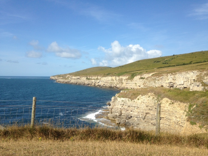
After a breakfast of oat cakes, bananas, strong tea and great views, the walk is underway by 8am, across an up-and-down, quiet path heading for St Aldhelm’s point. It is pretty obvious that on this section, where the narrow path is at times bordered by dense gorse bushes, that people have used it as a toilet and been indiscreet. Leaving their, shall we say detritus, on open view, flagged up by toilet paper and no attempt to bury it. Two joggers overtake with panted “hellos”. Their football shirts suggest they are not locals (23) before this lonesome backpacker is overrun by seven day-walking lads, heading for Kimmeridge Bay from Langton Matravers (30). Above Blackers Cove a herd of cattle milling round a water trough put me off grabbing a drink and force a steep diversion off the path to avoid their attention. A woman runner going through a training routine blanks me ‑ and she had a micro rucksack, so would have counted. Beyond Dancing Ledge there is a camp of young people, more pitched near Seacombe Cliff and again in a quarry at Winspit, all still coming round. They are camping in defiance of the “Don’t do anything round here” kind of signs that litter the area. Who could blame them, they are excellent spots right by the sea.

Sat on a bench just beyond the Radar Memorial and coastguard station at St Aldhelm’s the view to Chapman’s Pool, Houns Tout Cliff and in the far distance Lulworth Cove is mesmerising, and one to be savoured on a sun-kissed morning. A portly couple, with their equally portly chocolate labradors, sweat out a “brilliant view, isn’t it?” (32) after their steep descent and climb from Emmetts Hill. Half an hour at the bench, drinking water purchased at the coastguard station, leaves a buffer between me and the day-sack party seven, who, as pleasant as they are, cramp my solitude. The solitude is not to last long, because having climbed Emmetts Hill, there is an onslaught of walkers.
A woman in her sixties steps gingerly down the hill. “He’ll struggle up there when he has to climb,” she nods towards her husband who is on the route just walked (34). Heading into West Hill where the path follows the contours inland from Chapman’s Pool, the total hits 65 with walking parties littering the route and at a sheeps’ trough (SY961777) where filtered water is acquired by virtue of the Sawyer filter, the walking parties just keep coming and thrust the total to 94.

The return to the coast on the west side of Chapman’s Pool leads to a steep ascent on steps up to Houns Tout Cliff. (98). The views are majestic and looking back at Emmetts Hill offers a better panorama than the walk along Emmetts. In a gap between day walkers (110) there is an opportunity to grab a human-free photograph. Heading on to Clavell Tower the path is open and sandwiched between farm land and cliffs and is littered with single walkers lots of groups and several families. (156). Saying “hello” every other minute is becoming tedious, so as a distraction it is time to try to identify wild pitches. Although, for clarity’s sake, this is only window shopping. Of course, they are few and far between.
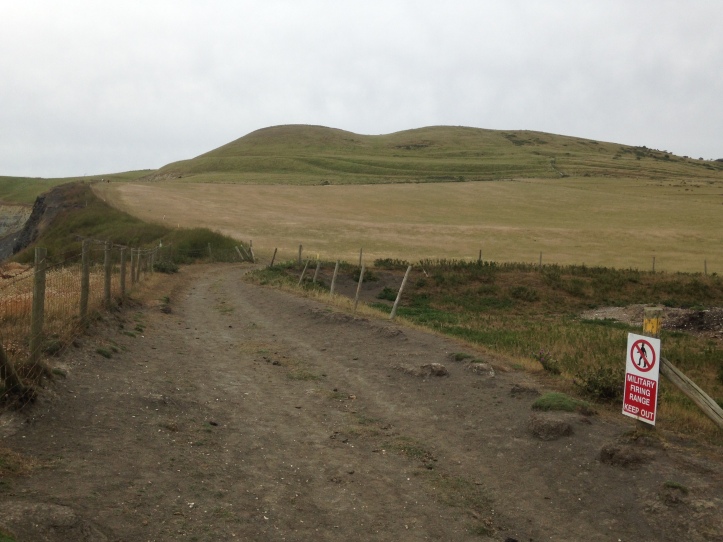
At the bottom of the steep descent from Clavell Tower (172) is a water tap in a car park and finally a loo. A chat to a Yorkshireman establishes that he is itching to be out backpacking instead of being, as he said, “on a family holiday”. He would not count. A Magnum ice cream at £2.50 from a vendor in the car park set me up for the ranges and Gaulter Gap, with warnings for Joe Public to keep to the path because of unexploded ordnance. Pity the sheep.
Range finder

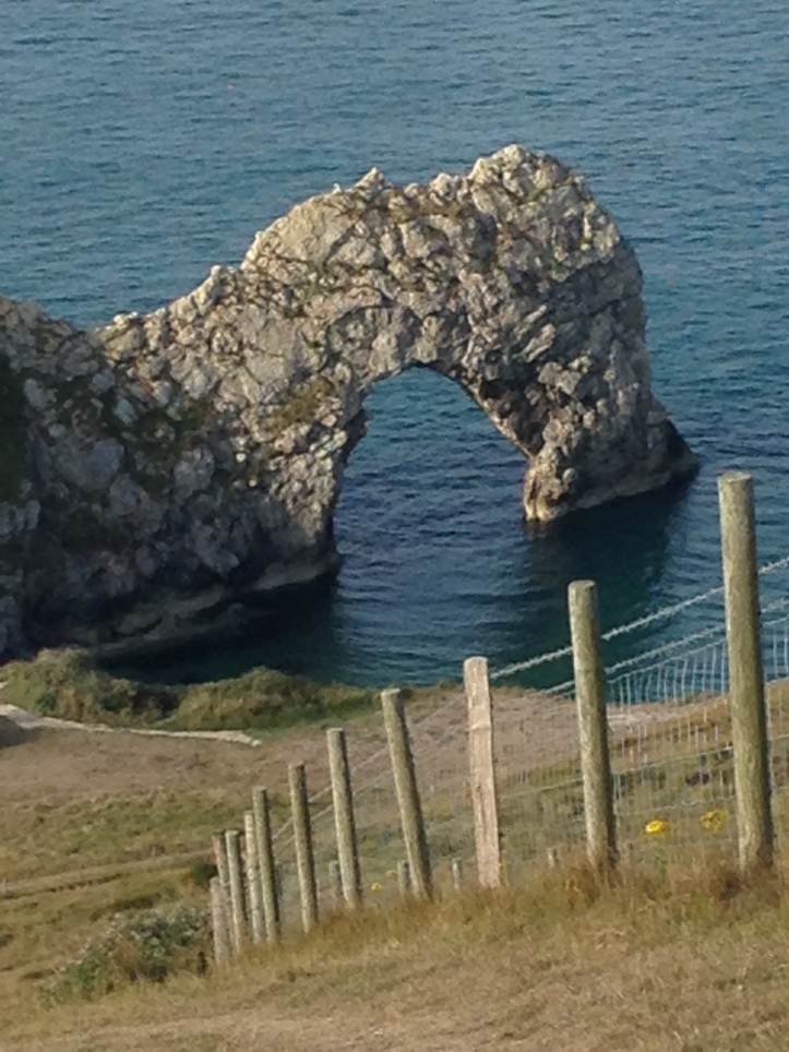
The next six miles into Lulworth Cove were majestic, with a spattering of walkers (196) at first but they are dispersed by the gathering gloom and the approach of teatime, leaving me with luscious isolation. A sharp climb up Tyneham Cap leads to a long sloping stretch of walk from Gad Cliff down to Worbarrow Tout. Beautiful vistas with a breeze and a touch of drizzle blowing in my face. On Worbarrow Tout there is what had appeared to be from Gad Cliff a bright coloured golf umbrella. Muttering under my breath “bloody litter louts” – it dawns on me, edging closer, that it is an artillery target. Doh! That and not seeing a fog horn, maybe it is time to visit Specsavers, Mr Magoo. There are a few more walkers, including the first backpackers, two of them. (201).
A steep pull up to Flower’s Barrow with Lulworth on the horizon provides still more beguiling scenery heading down to Arish Mell. For the section around Mupe Bay there is just me and the clouds. A local in Lulworth later that evening tells me about the line of abandoned tanks seen from above.
“Filled with concrete, they are,” he says. “That’s why there is an exclusion zone in the water. If a round deflects off ’em they end up in the sea, see.
“And they’d blow a yacht out of the water.”

There has been an exhilarating wild feel to the section through the ranges and the temptation to divert into Tyneham village, which from a distance appears to be awash with tourists, is avoided. Approaching Lulworth, in waterproofs, two sika deer bolt from gorse undergrowth, they have been surprised by me and equally they have been a surprise for me. They thunder away, their hooves boom off the earth. That is the last seclusion before the cove, where despite it being overcast and raining, crowds of people swarm over Hambury Tout. Eighty people are added to the total because people are walking the path and are not locals and many have rucksacks. (281).
Finding a wild camp would mean retracing my steps, or further climbs going west. The youth hostel is full. It is 8pm. Sometimes when knackered, needs must. Durdle Door campsite will have to do. In the clubhouse, after lasagne (from a freezer, probably ) and chips (no chilli noodles for me, again) washed down with a pint of cider, it is time to head for the tent and this bushwhacked backpacker is snuggled up and asleep not long after 10pm, oblivious to any noise that might have occurred at closing time.
Magnum force
Sunday, 6.30am, and with only crows and two dressing-gown clad female campers awake, oat cakes, cheese and tea are served. And it is back on the trail again by 8am, at Durdle Door, which is awash with Saturday night litter. Booze debris and Doritos packets, bottles and cans spilling out from bins across the grass. “Bloody litter louts”. On the beach sleepy-headed campers stir from their tents in the shadow of the stone hoop. So much for “no camping”.
Up to Swyre Head the early morning path is reserved for me and more smashed bottles – against a stone National Trail signpost. The breeze and light cloud gave way to a hazy sun. With the walk down to Bats Head, up to the beacon at West Bottom and along to Whitenothe Cottages the dramatic climbs were done. Five people are added to the total – two couples and a Usain Bolt of a walker as Whitenothe Cottages is reached and its views to Portland and Weymouth. The number of walkers on the path shoots up heading for Burning Cliff. The saying of “hello” is becoming tiring again – there is a pattern of intolerance emerging. (297).

The sea at Ringstead Bay, just before Ringstead Ledge, is too tempting. It’s time to go off-piste to the beach. Sunshine, sea, solitude. Who could resist? The pebbly water is clear deep blue, cold and exhilarating – ie bloody freezing – with a strong tidal pull. Still it is fantastic. Dried, refreshed and new foot-tread fitted, the trudge along the stones of the beach to the ledge then bears right along a track to Ringstead and a car park cafe that is full of people chomping all-day breakfasts. A Magnum – £2 this time – is washed down with a cold lime drink and it is a level walk along the coast to Osmington Mills.
The walking groups, because of the confluence with the South Dorset Ridgeway and the coastal path, grew in number. (A party of 17 another of 14, plus a couple from Lancashire pushed the total to 330). Two people from north Manchester decked out in the finest and newest gear stopped to chat. He is carrying all supplies for their day walk in a big Berghaus number with water pipes leading from here there and everywhere in the pack. She takes a drink as we talk.
“Where you off to?”
“It’s all in here,” he says, pointing to a gadget on his shoulder. It is satnav route that tells him in an irritating metallic voice when and where to turn and how far to walk.
“Doesn’t it take the fun out of planning and following a route on a map?”
“No, saves all that bloody faffing about,” he says looking at my map contained in a plastic bag. Fair point.
We smile. He didn’t know the name of the place that he was off to. Anyway, the couple make the count 332.
From Osmington Mills, which is dominated by The Smugglers Inn and was swelling with lunch-time boozers and eaters, the walk up the road and across Goggin’s Barrow and Black Head was gentle before sweeping down into Bowleaze and the seaside holidayscape of Weymouth. There were another 24 “hellos” (356) before reaching Bowleaze. The stretch into town is a cake walk. Two more walkers take the count to 358.
Chilli finale
Pretty unscientific, but by my reckoning, 358 “hellos” over 40 miles equals roughly nine walkers per mile – across one plus two half days and squeezed, as might be expected, into the middle part of the walking day. At a guess that number could be at least doubled with local dog walkers, people walking down to the beach and others. That must equal a whole lot of wear and tear.
From Weymouth the train progressed slowly through picturesque one-horse towns and luscious green countryside to Castle Cary, from where it was standing room only heading east. At home, mission accomplished, the well-travelled chilli noodles were finally scoffed.
God bless the South West Coastal Path!

top read
LikeLike
Cheers Bryan
LikeLike